Full 1
SATELLITE MONITORING WITH
ARTIFICIAL INTELLIGENCE SUPPORT

We created a SaaS platform that simplifies the use of geospatial data!

Full 1
Full 1
Forest Market
Accurate and efficient analyzes in a few clicks

For managers seeking to understand regional markets in Brazil, evaluating supply, demand and availability of wood.

Full 1
Full 1
FOREST MONITORING
COMPLETE CONTROL OF YOUR FOREST FROM PLANTING FOR SALE

For forestry producers who need to manage their forests without the high costs of complex software.

Full 1
Full 1
ENVIRONMENTAL COMPLIANCE/ESG
ASSESS ENVIRONMENTAL AND LAND RISKS WITH GEOSPATIAL INTELLIGENCE

For lawyers, experts and consultants who need to carry out land and environmental analyzes in a precise and uncomplicated way.

Full 1
Full 1
APPROVAL OF THE INNOVATIVE
PARANÁ NOTICE | 2023

MapForest was one of 80 startups chosen in the Paraná Inovador Notice, from the State Secretary of Innovation.

Full 1
previous arrow
next arrow
free-rocket-icon-3428-thumb.png

THE ORIGIN OF INNOVATION IN GEOSPATIAL MANAGEMENT​

MapForest is a startup (spin-off of Grupo Index) that was created with more than 50 years of experience in the agroforestry, energy and mining sectors.
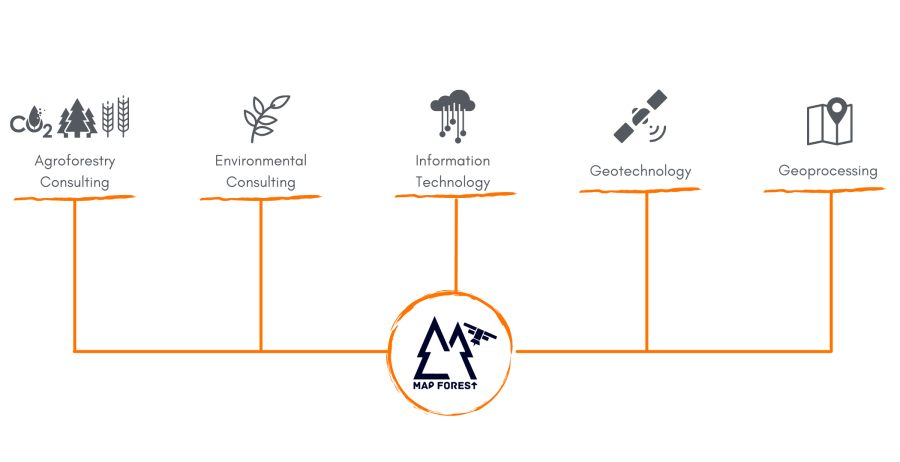
The Origin of Innovation in Geospatial Management

MapForest is a startup (spin-off of Grupo Index) that was created with more
than 50 years of experience in the agroforestry, energy and mining sectors.

Setores MapFOREST - Site

RECOGNITION AND PARTNERSHIPS THAT VALIDATE OUR JOURNEY

Association with SIF, a place where development and innovation in the forestry sector is promoted

Approval in 29th place in FINEP's Technology 4.0 Notice, with 1,192 candidates

Approval for Incubation at the Santos Dumont Accelerator, at the Itaipu Technological Park

Investment of approximately R$ 600 thousand in the Itaipu Technological Park

aws_logo_smile_1200x630

Funding for development

aws_logo_smile_1200x630

Approval in the Paraná Innovator Program

Reconhecimento e Parcerias que Validam Nossa Jornada

Association with SIF, a place where development and innovation in the forestry sector is promoted

Approval in 29th place in FINEP's Technology 4.0 Notice, with 1,192 candidates

Approval for Incubation at the Santos Dumont Accelerator, at the Itaipu Technological Park

Investment of approximately R$ 600 thousand in the Itaipu Technological Park

Funding for development

Approval in the Paraná Innovator Program

PRACTICALITY, RELIABILITY AND PRECISION IN GEOSPATIAL MANAGEMENT

GeoBI Platform
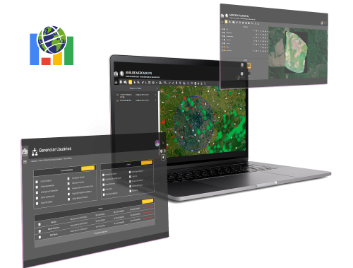
Telas-MapForest
  • Software as a Service (SaaS);
  • Project management;
  • Interoperability via API;
  • ESG compliance analysis;
  • Document Management;
  • Customized maps and reports;
  • Geographic Data Manipulation;
  • Management of users and work teams;
  • Mobile application for viewing and collecting data;
  • Integration between spatial analysis and Business Intelligence;
  • Artificial intelligence for productivity estimation and future projection simulations;
  • Artificial Intelligence applied to geospatial monitoring via satellite images;
  • Big Data fed by more than 50 public sources from all over Brazil.

Praticidade, Confiabilidade e Precisão em Gestão Geoespacial

Plataforma GeoBI

GeoBI Platform

Telas-MapForest
  • Software as a Service (SaaS);
  • Gerenciamento de Projetos;
  • Interoperabilidade via API;
  • Análise de conformidade ESG;
  • Gerenciamento de Documentos;
  • Mapas e relatórios customizados;
  • Manipulação de Dados Geográficos;
  • Gerenciamento de usuários e equipes de trabalho;
  • Aplicativo Mobile de visualização e coleta de dados;
  • Integração entre análise espacial e Business Intelligence;
  • Inteligência artificial para estimativa de produtividade e simulações de projeções futuras;
  • Inteligência Artificial aplicada ao monitoramento geoespacial via imagens de satélite;
  • Big Data alimentado por mais de 50 fontes públicas de todo o Brasil.

Plataforma GeoBI

  • Software as a Service (SaaS);
  • Project management;
  • Interoperability via API;
  • ESG compliance analysis;
  • Document Management;
  • Customized maps and reports;
  • Geographic Data Manipulation;
  • Management of users and work teams;
  • Mobile application for viewing and collecting data;
  • Integration between spatial analysis and Business Intelligence;
  • Artificial intelligence for productivity estimation and future projection simulations;
  • Artificial Intelligence applied to geospatial monitoring via satellite images;
  • Big Data fed by more than 50 public sources from all over Brazil.
  • Software as a Service (SaaS);
  • Gerenciamento de Projetos;
  • Interoperabilidade via API;
  • Análise de conformidade ESG;
  • Gerenciamento de Documentos;
  • Mapas e relatórios customizados;
  • Manipulação de Dados Geográficos;
  • Gerenciamento de usuários e equipes de trabalho;
  • Aplicativo Mobile de visualização e coleta de dados;
  • Integração entre análise espacial e Business Intelligence;
  • Inteligência artificial para estimativa de produtividade e simulações de projeções futuras;
  • Inteligência Artificial aplicada ao monitoramento geoespacial via imagens de satélite;
  • Big Data alimentado por mais de 50 fontes públicas de todo o Brasil.

HAVE QUESTIONS? CONTACT!

Please enable JavaScript in your browser to complete this form.
Nome

lgpd@mapforest.com.br

Contact and Social Networks

About MapForest