Challenge: Manage forestry plantations throughout the entire cycle, from planting to sale, with limited resources, without compromising efficiency.
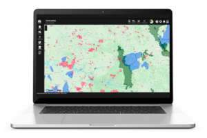
How we help: We offer an efficient and low-cost solution for forest management, allowing forest producers to have complete control of their forests, from planting to sale. With advanced geoprocessing and data analysis resources, we facilitate forest registration, data collection and insertion with our mobile app, document management, issuing invoices and estimating transport costs/logistics.
Who is it for: Forest producers, cooperatives and forest managers looking for an affordable and effective solution to manage their forests without the high costs and complexity of traditional software.
CLICK HERE AND TRY IT FOR FREE →